QUICK TRAIL FACTS
- Preserve Size: 209,644 acres
- Trail Mileage: Many miles
- Pets: no
- Difficulty: easy to challenging
- Sights: ponds, mountain views, waterfalls, pools
Map shows trails near South Branch Pond and Trout Brook Farm campgrounds. Traveler Loop in blue; South Branch Mountain trail in orange; Ledges Trail in red; Howe Brook Trail in yellow; South Branch Falls trail in pink. See Trout Brook Farm Campground trails.
It it enough to just hang out at the campground, and possibly paddle around Lower and Upper South Branch ponds on one of the park’s canoes or kayaks, to be immersed in this area’s beauty. But this is a hiking guide, so I really recommend getting out on the several trails that fan out from the campground! Several of them are super for young kids or painful knees/hips/ankles. There are also longer, very scenic ones for more experienced hikers.
Traveler Mountains Loop — A very tough 10.6-mile loop, with fantastic views and hard hiking!
South Branch and Black Cat mountains — An arduous hike, but less challenging than the Travelers Loop, on the other side of Lower South Branch Pond. Lovely views from Black Cat summit and ridge.
Barrel Ridge — A relatively easy hike, with a nice summit about 3.3 miles from the campground. The final 0.3-mile spur to the top is the steepest section.
Ledges Trail — This 0.7 trail has a gentle climb to a ledge with views over Upper South Branch Pond, and the tiniest peek of Lower South Branch Pond. It is a great one for kids.
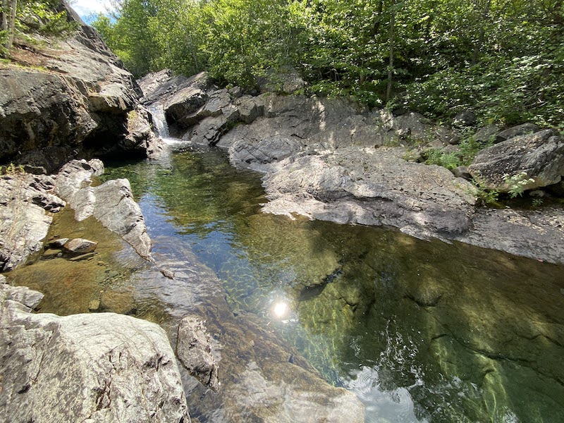
Howe Brook Trail — Another super trail for children, as it is relatively short and easy. From the campsite, you follow Pogy Notch Trail along the edge of Upper South Branch Pond for about 1 mile before turning inland. From this point, it is roughly .3 miles to the first pool with clean, clear, deep water. Two or three other pools and chutes worth visiting are just a bit farther along the trail. Then the path, while still lovely, becomes slightly less spectacular, until you emerge at 2.8 miles at the tall waterfall and pools below it.
South Branch Falls — Another kid-friendly hike! The .5-mile trail leaves from the access road to the South Branch Ponds Campground. The walking is easy, until the final few feet where the trail gets just a touch steeper as you descend to the falls. Actually, the trail emerges above the falls, which is nice change from many waterfall hikes. You’ll then cross a large shoulder of a boulder to make your way down to the crystalline aquamarine pool below the falls.
Here’s a great resource for hiking in Baxter State Park.
Directions: From Matagamon Gate, drive almost 6 miles to the entry road to the campground, on your left. Go 2.3 miles to the general parking area. The ranger’s station and pond beach is just a bit farther in.