QUICK TRAIL FACTS
- Preserve Size: 85 acres
- Trail Mileage: >2.5 miles in network
- Pets: yes
- Difficulty: easy to challenging
- Sights: Long Cove, Damariscotta River, Seal Cove
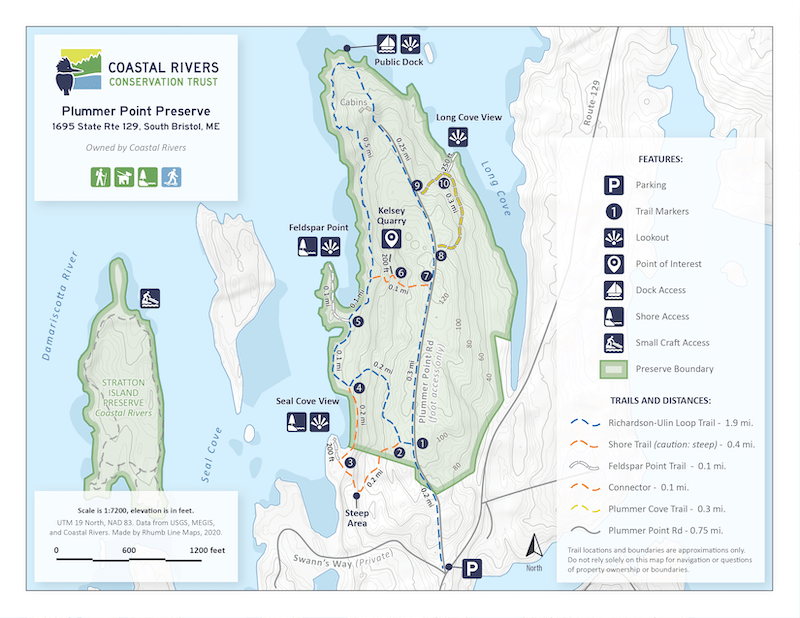
This 85-acre preserve includes a couple of loops that have lovely views of Long Cove and Seal Cove along the Damariscotta River. There are more than 2.5 miles of trails.
To reach the footpaths along the waterfront, you first walk along an old gravel road that is smooth enough for most wheelchairs. From the trailhead kiosk to the two small cabins close to the point, the distance is about 0.8 miles, according to my GPS. When you reach the cabins, the footpath diverts from the road, passing close to the right of one cabin, and slopes gently down for about 0.1 mile to the shore and dock area.
At the point, you’ll find a picnic table and deep water dock, and rocky ledges to explore. On hot days, it might be tempting to jump in for a swim.
The walking is easy on the access road, but once you leave it for the footpaths, the going gets rougher and steeper in areas, especially as you head down the relatively steep embankments to the water, and also when you walk along Seal Cove. But the views are glorious-well worth the effort.
Directions: From Route 1 in Damariscotta head south on ME 129 for 10.8 miles to South Bristol. The preserve is on your right and is marked with a preserve sign. There are a few spots available on the wide road shoulder. You can enter the preserve by walking up the dirt road beyond the gate.

