QUICK TRAIL FACTS
- Preserve Size: 14 acres
- Trail Mileage: ~ 1 mile in network
- Pets: yes
- Difficulty: easy
- Sights: river, sandy beaches
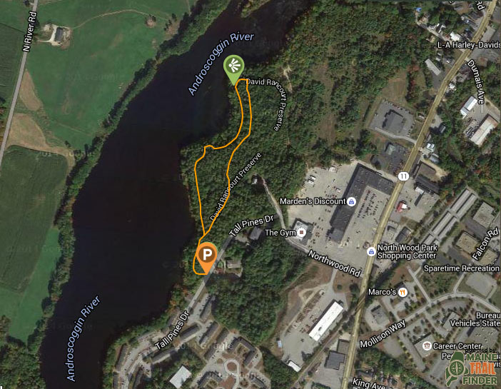
This 14-acre preserve, owned by the Androscoggin Land Trust, contains two little sandy beaches along the Androscoggin River. Because this spot is close to the city, they’re not the cleanest beaches in the world, but they have charm. People have had beach-side bonfires out here. The trail is near a subsidized housing community, which is nice, and it also connects to a Marden’s super store! This can make for a nice after-walk shop if you’re looking for some discounted thing or another. The preserve was named after David Rancourt, a deputy sheriff who was clearly well-loved. There is a loop marked with yellow blazes. The trail system connects with another trail that continues along the river.
Directions: From downtown Lewiston, follow Main Street (Route 202) north until you go past Mollison Way on the right and then under the railroad bridge. Take a left at Northwoods Road (just before Marden’s). Follow Northwoods Road a short distance until the road changes to Tall Pines Drive at a 90 degree turn to the left. Follow Tall Pines Drive a short distance past two townhouses. Park along Tall Pines Drive along the wooded section immediately across from a private parking lot of the second townhouse at 20 Tall Pines Drive. Look for the kiosk and the trailhead.

