QUICK TRAIL FACTS
- Preserve Size: 209,644 acres
- Trail Mileage: +10 miles
- Pets: no
- Difficulty: challenging
- Sights: Views! Remote pond, cold streams
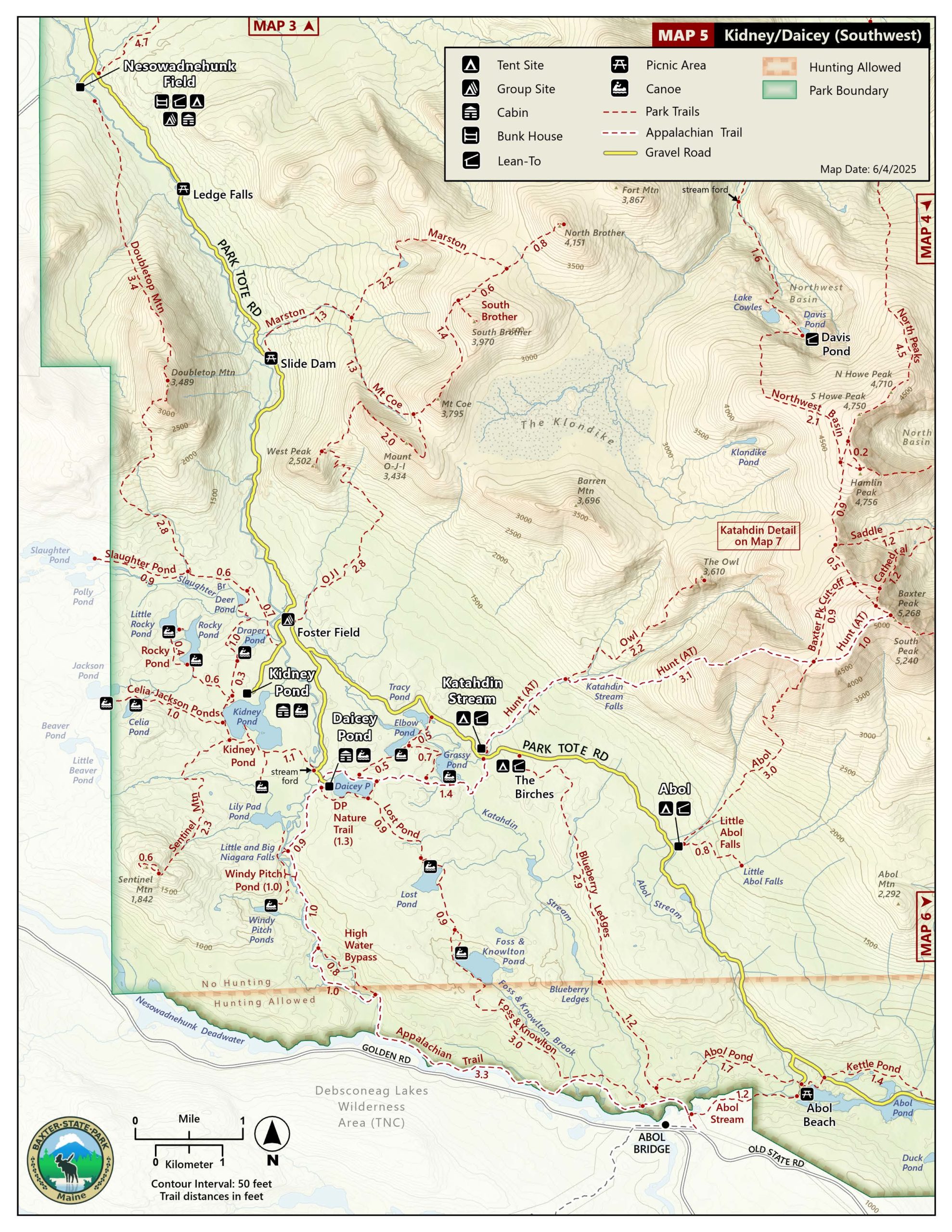
Mt. Coe-South Brother-North Brother loop in red; Mt. O-J-I in blue.
Baxter State Park has created a magnificent loop (about 10 miles according to my park map) that connects North Brother, South Brother, and Mt. Coe. When you’re not on exposed mountaintops, you’re mostly in mossy forest.
North Brother, at 4,143 feet, attracts a lot of the 4,000-foot peak baggers who want to hike every mountain higher than 4,000 feet in New England. South Brother is 3,960 feet and Mt. Coe stands at 3,784 feet. These are rough estimates for elevation gains from Slide Dam: 2,594 ft. for Mt. Coe, 2,770 ft. for South Brother, and 2,953 ft for North Brother.
Because the trail to the summit of Mt. Coe follows a precipitous rock slide for at least half a mile, park rangers suggest hikers do this loop counter-clockwise, climbing Mt. Coe first and then heading over to South and North Brother.
The loop begins at a parking area near Slide Dam, off the Tote Road, which is a great place to swim after your hike! The first leg of the loop on the Marston Trail follows a brook for 1.3 miles to the first junction. Go right to follow the rangers’ recommendation and climb the gravelly, steep, slippery slide up Mt. Coe. Be very careful, and make sure you have hiking boots with good traction. You’ll reach the top of Mt. Coe in about 3.2 miles. Views are great, supposedly! We only saw fog. If you’re continuing on to the Brothers, it’s another 1.3 miles or so to the 0.3-mile leg up to the top of South Brother, a steep climb up a rocky path.
From South Brother, once you’re down from the summit, it’s a fairly easy 0.6 miles or so to North Brother. The 0.8-mile leg up to North Brother’s summit is another arduous climb, but the boulder-strewn, barren summit is incredible. Or so I hear. We had five feet of visibility! I’ve added our friend Nina Hagel’s photos here since she climbed North Brother on a clearer day. The summit of North Brother offers a look into the interior of the park, as well as great views all around.
By the way, if you walk just to North Brother, starting on the Marston Trail, you’ll find that the hike offers a nice rhythm of steep, flat, (very) steep, (relatively) flat, (very) steep, giving your legs a bit of break in between ascents. You’ll also pass by the pretty Teardrop Pond at around 2.1 miles, which you’ll also be able to look down on from higher up on the ridge.
The park provides good online maps of its different regions.
Directions: The parking area for the Marston Trail is close to Slide Dam, off the Tote Road, about halfway between Ledge Falls and Foster Field. You can also hike to North Brothers from Mt. O-J-I, which has a trailhead at Foster Field.


Your description of the 0.8 trail up North Brother as arduous is accurate–washouts, roots and boulders, and summit views are outstanding (I was lucky!) Great site you’ve put together btw. Cheers!